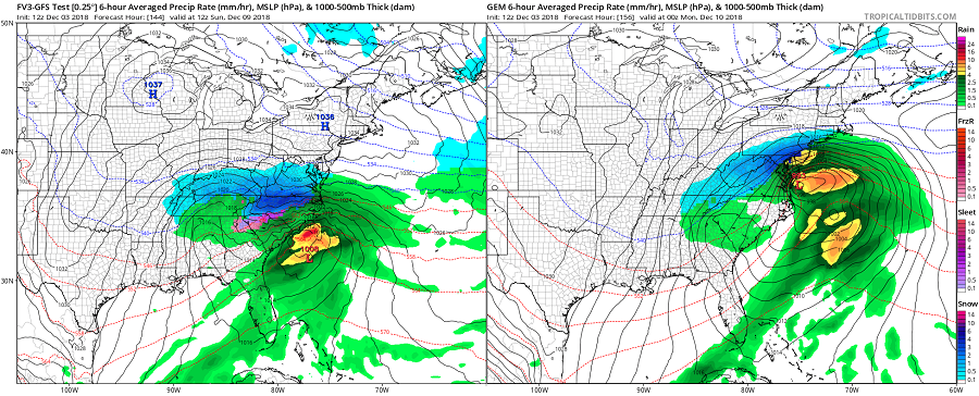
While there’s been a signal in forecast guidance that a winter storm would impact portions of the U.S. East Coast this coming weekend for a while, confidence in such a scenario has only grown significantly in recent days. While meteorologists can confidently say a winter storm will impact the East Coast, unfortunately, there’s a lack of weather data and an understanding of how the atmosphere will evolve to allow for an area of low pressure to travel along the coast or out to sea. As such, while confidence that a storm will form is high, there is no confidence yet in who will see what kind of precipitation over the weekend. Clues for how things will evolve on the East Coast next weekend remain over the Pacific today: meteorologists need to understand the influence of a Pacific stream on the storm to determine if the storm will hook up the coast or head out to sea. It likely won’t be until Wednesday evening when enough data is sampled around the Pacific to understand what, if any influence, this will have on the East Coast storm track.
Joining the Pacific stream to determine where this storm will head is also a Polar stream. If conditions are just perfect, the influence of these two streams can lead to a historic east coast snow storm, as is the case sometimes over some winters. It is unlikely such a scenario would unfold now, especially this early into the young meteorological winter season that only began days ago. Instead, there are three possible scenarios that are being tracked. The first would be if the Polar stream is moving too slow while the Pacific stream is moving too fast, a scenario suggested by most forecast models yesterday. If this were to happen, while a winter storm would blossom over the interior southeast, it would continue east without hooking up the coast, bringing snow to the southern and central Mid Atlantic but not much of anything else further north. Today’s afternoon run of the American GFS forecast model continues to suggest this will happen, bringing a significant early season snowfall to portions of Kentucky, North Carolina, and Virginia, while places like Maryland, Delaware, and points north would see mainly clouds, if anything at all. The second possible scenario would be if both the Polar stream and Pacific streams are moving fast. This would yield a solution similar to the first, with a storm being sped off to the ocean. If it moved quickly enough, precipitation would be light to moderate across the central and southern Mid Atlantic. The third scenario would be if the Polar stream sped up while the Pacific stream slows down; this would allow the storm system to hook up the coast, bringing snow to the north Mid Atlantic and southeastern New England. The Canadian CMC model suggests the third scenario would unfold. The European ECMWF model has been inconsistent with its solutions, suggesting any one of the three scenarios at any time. In the latest afternoon run of the European model, it does join the American GFS in a system that is shunted to the south and out to sea. Whether it keeps such a solution in tonight’s run remains to be seen.
For now, residents from North Carolina to Rhode Island should continue to monitor this evolving system, knowing that a firm idea of how those Polar and Pacific streams will work likely won’t be known before Wednesday night. Someone will see significant snow -more than 6″- now it’s up to meteorologists to figure out exactly where that’ll happen in the coming days.
