 More severe weather is likely today as a multi-day outbreak continues.
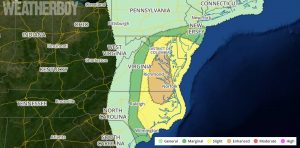
Scattered severe storms with damaging winds, large hail, and a couple of tornadoes will be possible through about midday to early afternoon across the Mid-Atlantic. A marginal wind and hail risk
will diminish slowly this morning across central Florida.
Secondary cyclogenesis is underway near the Blue Ridge in northwest Virginia, where 3-6 mb pressure falls per two hours have been observed in advance of a negative tilt shortwave trough accelerating northeastward over the southern Appalachians. The northwest Virginia cyclone will deepen and move north-northeastward to eastern Pennsylvania by early-mid afternoon. A trailing cold front will move off the North Carolina coast by lunchtime, and the remaining warm sector near the DelMarVa Peninsula will be pinched off by dinner time.
Overnight convection has lingered near the North Carolina coast, and anvil cirrus has overspread eastern North Carolina and southeastern Virginia this morning. Low-level moisture inflow across eastern North Carolina/Virginia has been disrupted and reduced by this convection, and the clouds will likely slow surface heating prior to frontal passage. However, strong forcing for ascent and modest moisture recovery ahead of the front will support a severe-storm risk until the cold front moves offshore this afternoon. Very strong deep-layer shear and conditionally unstable midlevel lapse rates will support a risk for damaging winds and marginally severe hail with embedded cells/line segments, and an isolated tornado or two cannot be ruled out with fast-moving cells.
The concentration of severe weather today will be over eastern North Carolina and Virginia, but the threat for severe weather extends into central New Jersey and southeastern Pennsylvania. When thunder roars, head indoors!
